
The Eagle-Holy Cross Ranger District of the White River National Forest (WRNF) has officially posted and is soliciting comments on 3 trail projects.
The three (3) projects proposed by the Forest Service are:
- Mill Creek Trail reroute
- Build an uphill trail adjacent to Vail ski area
- Build a North Trail connection between existing Red Sandstone paved parking lot trailhead with the Red Sandstone dirt road trailhead.
These projects are currently under review per the National Environmental Policy Act (NEPA) and are not approved at this time. What is NEPA you ask? Well that’s a much longer and different post but NEPA requires federal agencies to assess the environmental effects of their proposed actions prior to making decisions. The range of actions covered by NEPA is broad and includes:
- making decisions on permit applications,
- adopting federal land management actions, and
- constructing highways and other publicly-owned facilities.
Using the NEPA process, agencies evaluate the environmental and related social and economic effects of their proposed actions. Agencies also provide opportunities for public review and comment on those evaluations.
We have been involved and will continue to be a part of at least two (2) if not three (3) of these projects if they are approved. However, the only project that we have proposed is the North Trail connection. The two projects in/adjacent to Vail Mountain are projects that stem from Vail Resorts decisions and initiatives. In short, we will be submitting comments supporting all three projects but they all have different circumstances. We are here to give you background and our thoughts on all three projects.
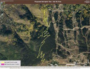
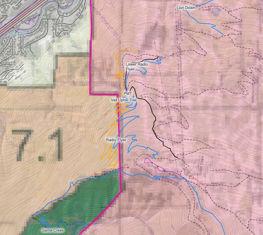
Vail Uphill Trail:
While we do support this and believe that an uphill trail on Vail Mountain is a great addition to its trail system, this was not proposed and is not a priority of the VVMTA’s. We have been involved in reviewing the alignment and if time and resources allow, may provide our resources to help build the trail if it is approved. Vail Mountain’s goal with this uphill trail is to increase safety for both mountain bikers climbing mountain roads and its staff driving vehicles for necessary mountain operations. The uphill trail would connect with the shoulder of the Game Creek trail and also connect with the bottom of Radio Flyer and PMT which would offer loop opportunities. The proposed map does not show a section of the uphill trail that Vail Mountain may build in the future inside its permitted ski area boundary on the lower part of the mountain which would provide shorter loop opportunities and further mitigate human and vehicle conflict.
Wildlife:
The Vail Uphill Trail is not located in critical habitat or migration corridor (elk, deer, bighorn sheep) as mapped per the Colorado Parks & Wildlife (CPW). While we understand that mapping is not perfect, it is created from data and science collected in the field.
Forest Plan:
Almost half of the proposed trail is located within Vail Mountain’s permitted ski area boundary. The portion of the trail on National Forest land is located within an area managed and designated as 7.1 Intermix. The Forest Plan manages 7.1 Intermix as following:
Theme: Areas characterized by an interface between National Forest System lands and other public and private lands are managed to protect natural resources, provide compatible multiple uses, and maintain cooperative relationships between private landowners and other governments with jurisdiction. Opportunities to consolidate landownership patterns are pursued.
Management Area Description: These areas are located along the borders of the forest, adjacent to other public and private lands. The private lands are usually undergoing pressure from urban and private residential development. Cooperative relationships are emphasized with other agencies, local governmental jurisdictions, and adjacent landowners. Opportunities are sought for coordinated, multi-jurisdictional management approaches to address resource issues and impacts that transcend the national forest boundary. Management actions are geared toward influencing the vegetation composition and structure to promote visual screening and to minimize hazardous fuel loading patterns.
Desired Condition: Wildlife habitat provides adequate cover for big game species between winter and summer ranges. Wildlife viewing is encouraged in areas not identified as winter range or sensitive habitats, and discouraged in those habitats considered sensitive. In high recreation-use areas, human disturbance may limit viewing opportunities to those species that are common or accustomed to the presence of people. Aquatic habitats that provide for recreation fisheries are protected. Opportunities for solitude are limited. Sights and sounds of human development are evident. The area is accessible for use by visitors, while conflicts with adjacent landowners are minimized to the extent compatible with overall management objectives. Land ownership patterns are simplified. Clearly identified property boundaries and acquisition of rights-of-way are a priority. Both motorized and non-motorized recreation activities are provided. The recreation opportunity spectrum (ROS) for this management area is semi-primitive non-motorized, semi-primitive motorized, roaded natural, or rural year-round. Scenery is managed to provide a range of scenic integrity objectives from low to moderate.
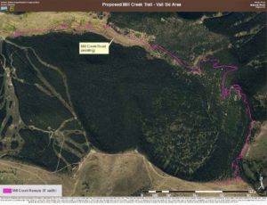
Mill Creek Reroute:
This one is quite a bit more complicated! First, we will state that we did not initiate this project but are excited about the opportunity it offers. Mill Creek Trail/Road as we currently know it is required to be decommissioned by Vail Resorts due to their proposed and approved Golden Peak expansion decision by the Forest Service. We have been advocating for continued access in the Mill Creek area because there is a chance all access could be lost. Rerouting Mill Creek Trail/Road has not been a priority of the VVMTA’s but we believe it is a very exciting trail project that will greatly improve trail connections and provide an incredible trail experience as well as continue to offer trail access in this area.
Background:
In March of 2019 the WRNF released its final Record of Decision (ROD) on the Golden Peak Improvement Project which if you look up at Golden Peak you can see the results of providing a world class ski racing/training venue in partnership with Ski & Snowboard Club Vail. During the environmental review of the project and included in the ROD, it states:
“The Selected Alternative (Decision) includes approximately 1 mile of new road and additional buildings and storage areas. These equal approximately 3 acres of new and permanent impermeable area in the Mill Creek watershed. Because of the effects of the Selected Alternative on low stability reaches of Mill Creek, the project must be mitigated (Watershed Conservation Practices Handbook [WCPH] Management Measures 1, 2, 9, 12; Forest Plan Standards and Guidelines for Colorado River Cutthroat Trout, Standards 1–4).5 Successful mitigation will include restoring hydrologic function at other locations in the watershed, encouraging infiltration of collected water in the newly developed area, and enhancing low stability reaches of Mill Creek.”
“The required mitigation, for which Vail Mountain Resort will be responsible, includes approximately 7 miles of ripping, re-contouring, improving drainage, and restoring native vegetation on Mill Creek Road/Trail. The existing Mill Creek Trail is located within the resort’s SUP for the first mile. The mitigation of the Mill Creek Road/Trail will meet needs from several resource areas including hydrology, soils, fisheries, wildlife, botany, recreation, and scenery. Implementation of the trail restoration project will be completed by the project proponent with oversight by the Forest Service via a cost recovery agreement.”
In short, due to the increased impacts on the Mill Creek watershed from construction and new facilities of the Golden Peak project, Mill Creek Trail/Road as we know it must be decommissioned to offset impacts of the project. Mill Creek Road/Trail is eroded and soils/runoff regularly impact the Mill Creek watershed which are only exacerbated by the new impacts from the Golden Peak project. Decommissioning Mill Creek Trail/Road is a benefit to the Mill Creek watershed and the Native Cutthroat Trout that live in it.
However, we were very concerned that trail and recreation access was going to be lost in the area because the approved decision only states that Mill Creek Road/Trail is to be decommissioned. It does not state a new trail must be built and continued public recreation access is maintained. We did not want to rely on others to ensure that a new trail was built to provide continued access. During the review of the Golden Peak Improvement Project and ever since the approved decision, we have been advocating for continued trail and recreation access which as a result is this proposed reroute.
Reroute Alignment:
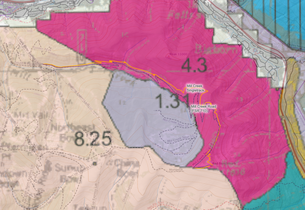
As stated above, we are super excited for this new 6-7 mile singletrack trail! If approved, the non-motorized multi-use trail will be built between the current bottom of Mill Creek Trail/Road and the very top of Benchmark at 11,818′. To help further mitigate impacts to the Mill Creek watershed it will be aligned above the existing trail/road and away from the creek and built to sustainable standards ensuring erosion and soils are not entering the creek.
The new trail will take users through different types of terrain including old growth pines, incredible Gore Range views, large rocks, star wars like aspen stands, and more. Mill Creek has historically and predominantly been used as a climbing trail for mountain bikers and long distance trail runners. This new trail alignment will keep grades and sight-lines that allows an enjoyable climb but now also offers a 6-7 mile descent of almost 3,000′. Our goal is to keep the trail tread width to 18″-24″ to maintain a backcountry trail experience. If approved, the trail will be built by a professional trail contractor, the VVMTA Trail Conservation Crew, volunteer trail days, Forest Service trail crew, and the Rocky Mountain Youth Corps. Funding for this project and the VVMTA Trail Conservation Crew’s portion is thanks to the Great American Outdoors Act and the National Forest Foundation’s White River Ski Conservation Fund. We hope to begin this project as weather allows after June 1, 2022 and complete before snow flies in the fall! Decommissioning of the existing Mill Creek Trail/Road will not occur until the new trail is built and open.
Lastly, but certainly not least, the new trail will provide seemingly endless singletrack trail connections. For example, and not for the faint hearted, pedal up Cougar Ridge, across Grand Traverse (and its new extension), descend Mill Creek, traverse across Vail Mountain to Game Creek, and descend Game Creek back to Minturn.
Forest Plan:
Per the Forest Management Plan, the Mill Creek Trail as proposed is located within and near areas managed for recreation; 4.3 Dispersed Recreation, 1.31 Backcountry Recreation – Non-motorized, and 8.25 Ski areas – Existing Potential. The new Mill Creek Trail alignment is entirely located within the 4.3 Dispersed Recreation management area which states:
Theme: The areas may be designated as either motorized or non-motorized. The non-motorized areas will usually have good vehicular access to a central parking area from which the non-motorized use originates.
Management Area Description: Dispersed recreational opportunities include viewing scenery and wildlife, dispersed camping, picnicking, fishing, snowmobiling, cross-country skiing, and mountain biking. Opportunities for solitude are limited. A broad range of management activities, including grazing, may occur. Facilities may be present to provide for health and sanitation, to protect resources, or to enhance the recreation experience. These structures may range from small resorts and campgrounds to fire grills, signs, or vehicle barriers. Roads are generally open to motorized activities. The travel system may include motorized and non-motorized trails. A wide variety of backcountry recreation opportunities exist as long as they do not interfere with maintaining a natural-appearing landscape. Resource management activities are compatible with, and reduce impacts to, recreation resources and opportunities.
Desired Condition: Biological communities are maintained or improved to provide an attractive setting for visitors, complement the recreational values, and provide varied plant communities, structural stages, and associated wildlife. Habitat for sensitive species will be protected and maintained, and may also be enhanced where such opportunities exist.
Wildlife:
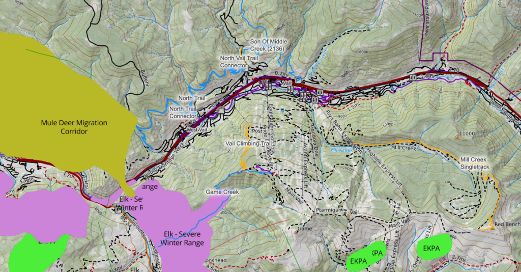
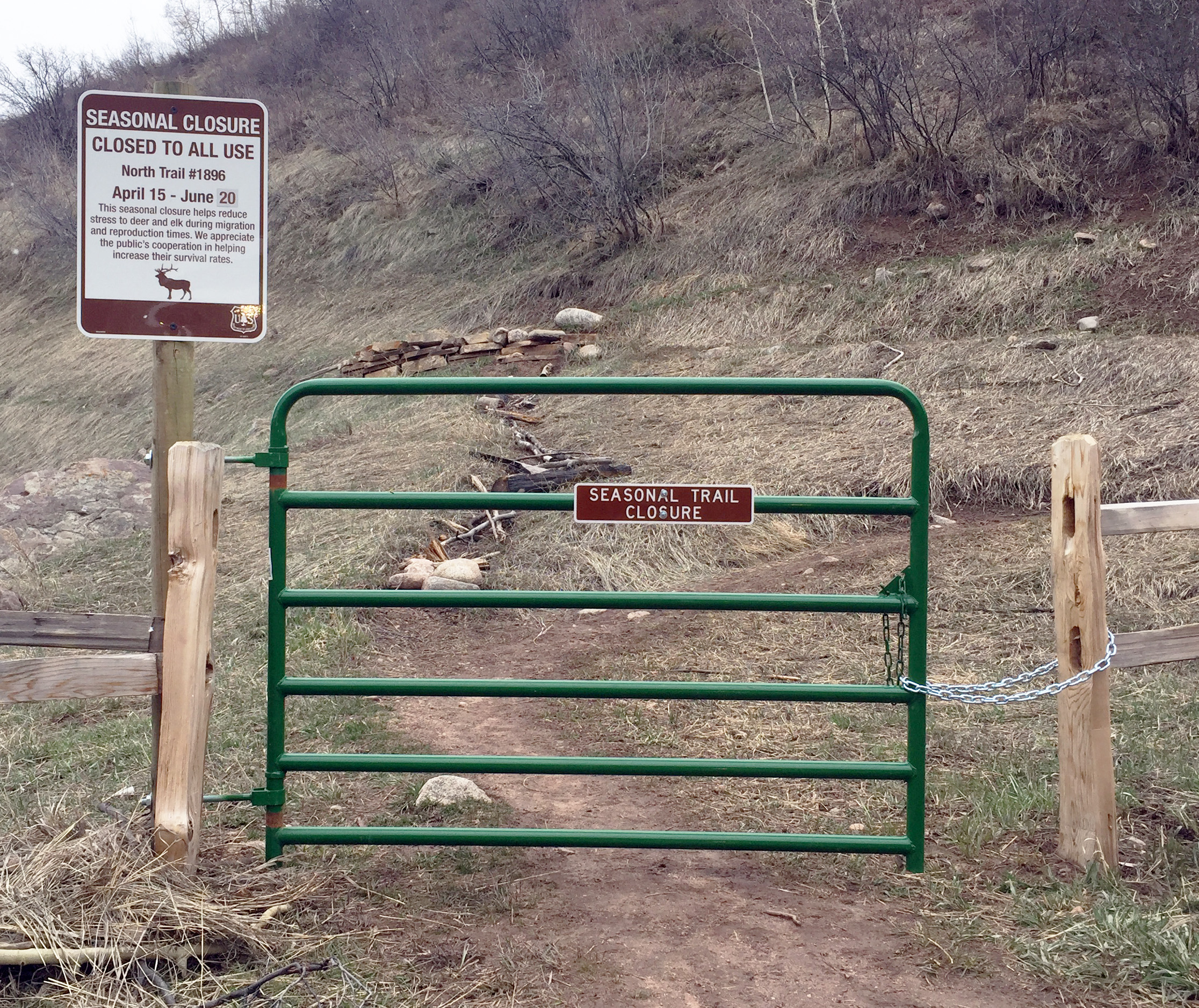
The Mill Creek Trail is not located in critical habitat or migration corridor (elk, deer, sheep) as mapped per the Colorado Parks & Wildlife (CPW). While we understand that mapping is not perfect, it is created from data and science collected in the field. Furthermore, to mitigate any potential wildlife impacts during the spring migration and calving season, we recommend installing signage at the bottom (north) and top (south) trailheads to inform users that the Two Elk Trail and area has a seasonal closure of May 6-June 1. We recommend that gates, similar to other seasonally closed trails, be installed on the Two Elk Connector to stop users from entering the back bowls area during this time.
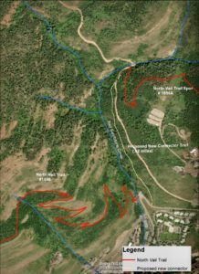
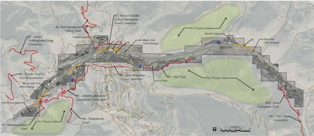
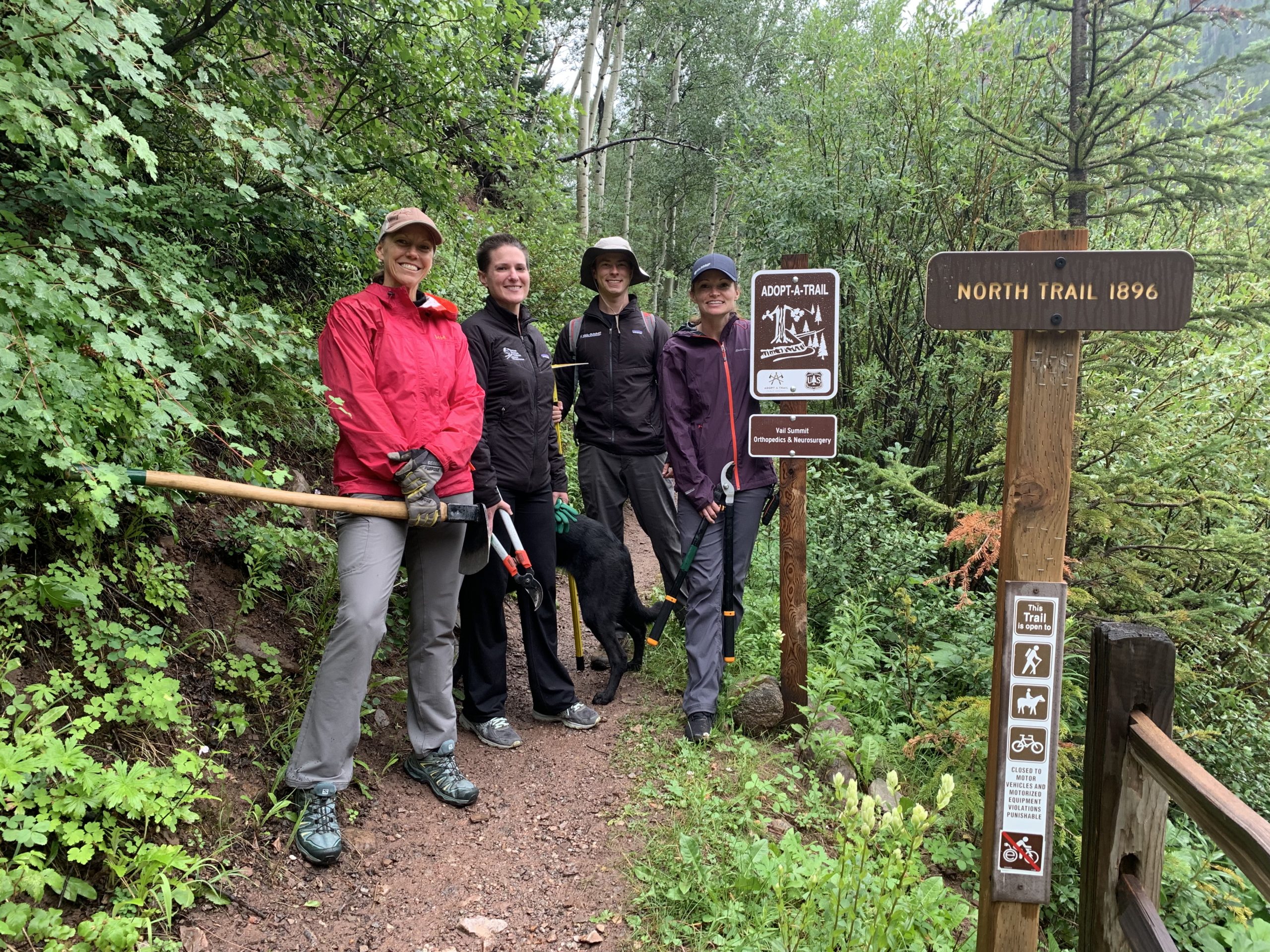
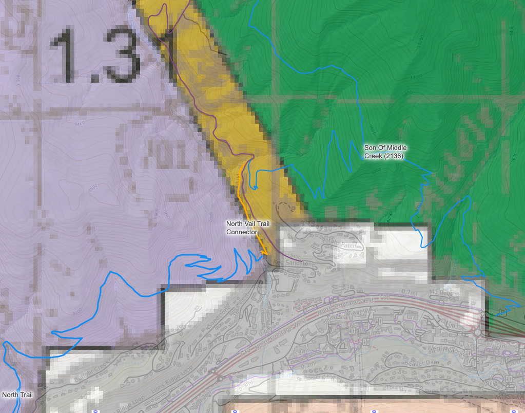
North Trail Connection:
The North Trail Connection will create a desired singletrack trail connection of the entire North Trail and improve the safety and experience for trail users. We proposed and strongly support this trail connection knowing that the benefits significantly outweigh any perceived or potential negative impacts. This connection was also identified and included in the Town of Vail Open Lands Plan that underwent thorough agency and public vetting and approved in 2018 that states:
- “Proposed multi-use trail connecting Vail to existing and proposed trails in the forest north of Vail. This soft-surface trail parallels Red Sandstone Road and Piney Lake Road to provide a much safer alternative by providing trail users an alternative to Red Sandstone Road. This trail, if deemed feasible from a design and wildlife impact standpoint, will need to be “tight” to Red Sandstone Road in order to minimize habitat fragmentation and impacts from trail use.”
Wildlife:
We would not have proposed to build this trail three years ago because of the amount of seasonal wildlife closure violations. That would not have been responsible of us and would directly conflict with our values, mission, and vision. However, largely due to the successes of the Wildlife Trail Ambassador program, our amazing volunteers, and continued community education we see violations significantly decreasing in the area. We now feel that it is responsible and we are confident in proposing this trail knowing that a large majority of trail users understand and respect seasonal wildlife closures. We will ask our Wildlife Trail Ambassadors to focus their efforts on this new trail, if it is approved, to ensure our community and visitors understand it is closed from April 15-June 20 to protect critical deer and elk habitat. As noted in the Town of Vail Open Lands Plan, this trail will be kept “tight” to the road to minimize habitat fragmentation.
The North Vail Trail Connector is not located in critical habitat or migration corridor (elk, deer, bighorn sheep) as mapped per the Colorado Parks & Wildlife (CPW). While we understand that mapping is not perfect, it is created from data and science collected in the field. Furthermore, to mitigate any potential wildlife impacts during the spring migration season, we recommend the North Vail Trail Connector to have a seasonal wildlife closure consistent with the existing North Trail and Son of Middle Creek Trails of April 15-June 20. VVMTA Wildlife Trail Ambassadors would focus on this new trail to ensure users are educated and understand the importance of this seasonal closure.
Benefits and Goals:
This short trail connection has many reasons and benefits including:
- Safety: We placed a trail counter on the dirt lower Red Sandstone Road from June 30-November 23 this past year that clocked 50,148 counts (missing an estimated 6,500+ before June 30). We can’t specifically state counts of cars vs. trail users but anecdotally and conservatively, we feel comfortable with saying 95% of the counts were vehicles. Normally, trail counts are divided by two to account for returning trail users. But in this case, as a trail user, a car speeding and kicking up insane amounts of dust on this road from behind or in front has the same impact both ways on safety. Additionally, this does not even account for the cars on Potato Patch Drive that trail users encounter leaving or returning to the Red Sandstone paved parking lot/trailhead. The Town of Vail website currently directs hikers to hike up Potato Patch Drive and Red Sandstone Rd for 1 1/4 miles to reach the North Trail/Son of Middle Creek Trailhead which if anyone tried, would have a horrible experience and likely never venture to these trails again.
- Trail User Experience: This connection significantly improves the singletrack experience of the North Trail for all trail users. Trail users can now park at the Red Sandstone paved parking lot and access the North Trail/Son of Middle Creek area trails without stepping foot or putting rubber down on paved or dirt roads heavily trafficked.
- East Vail Trails Mitigation: By creating a desirable and safer trail connection and experience in this area, it will draw trail users away from the overcrowded East Vail Trails and mitigate impacts on the Eagles Nest Wilderness Area.
- Future Connections: We see this as a desired and needed trail connection but also as a “Phase 1” approach to a much more cohesive, safe, and improved experience of a North Vail Trail System. As identified in the Town of Vail Open Lands Plan, a conceptual “Phase 2” trail connection would continue to move trail users off of Red Sandstone Rd by connecting the North Trail to Son of Middle Creek upper trailhead via an additional tight trail to the road. From here, a conceptual “Phase 3” trail would continue the same theme and connect trail users from Son of Middle Creek to Buffehr Creek. Now that is creating a great trail system for our community and visitors to enjoy in an area that is already heavily recreated, trafficked, and used! For any of these ideas to become reality, we need to continue to respect seasonal wildlife closures and educate as many trail users as possible about the importance of them.
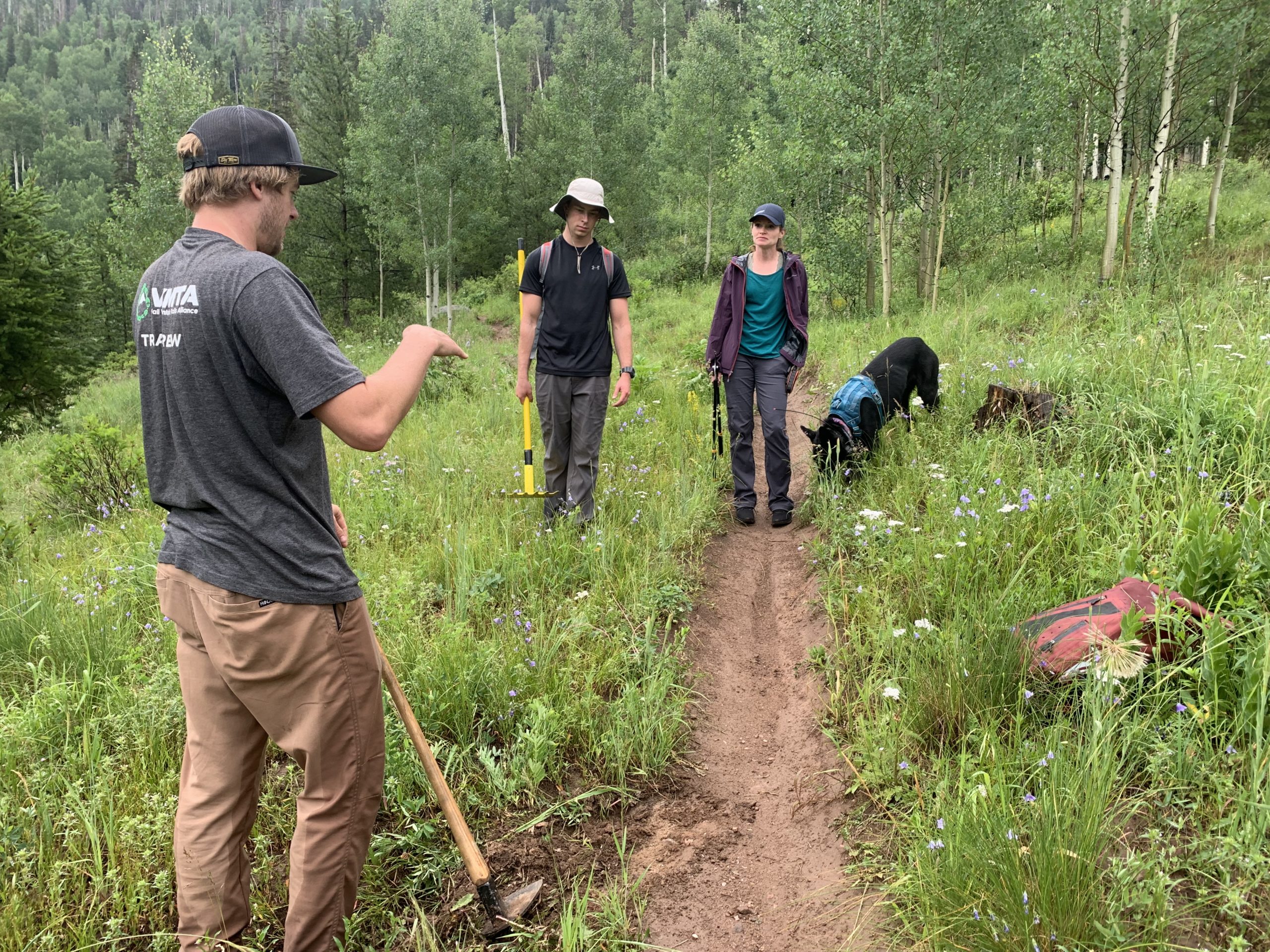
- Volunteer Stewardship: If approved, this trail would be entirely hand built by our community of volunteers. These volunteers would be taught the techniques of sustainable trail designs and the importance of seasonal wildlife closures.
Forest Plan:
Per the Forest Plan, the North Vail Trail Connector is located within an area managed as 1.31 Backcountry Recreation – Non-motorized and a Utility Corridor 8.32. The Forest Plan manages 1.31 Backcountry Recreation – Non-motorized as following:
Theme: Backcountry, non-motorized recreation areas are managed to provide recreation opportunities in a natural-appearing landscape. These areas, usually 2,500 acres or larger, are generally unroaded or may have some evidence of past roads. They are natural or natural-appearing with little evidence of recent human-caused disturbance. They are important for providing non-motorized recreation near the primitive end of the recreation opportunity spectrum.
Management Area Description: A variety of year-round non-motorized recreation opportunities are provided in a natural or natural-appearing setting. Improvements such as trailheads, trails, signs, bridges, fences, huts, or shelters that enhance the recreational opportunities may be present. Trails provide challenging hiking, horseback riding, cross-country skiing, snowshoeing, or mountain biking opportunities. No road building occurs within the area. Noise from motorized use is a rare exception away from the area boundary.
Desired Condition: The recreation opportunity spectrum (ROS) for this management area is semi-primitive non-motorized year-round. Scenery is managed to provide a range of scenic integrity objectives from moderate to very high.
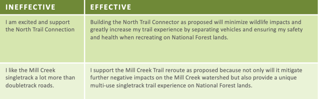
In conclusion, we want to first thank our partner, the Eagle-Holy Cross Ranger District of the White River National Forest, for proposing, accepting feedback, and reviewing these projects. They are all great additions to our trail system which we fully support and hope are approved. But in order for them to be approved, we need your supporting comments, feedback, and hopeful time and resources to get them built! The comment period is open until February 7, 2022 and we encourage you to submit your comments. If you do submit comments please follow these guidelines, otherwise they will be discarded:
- Be specific about actions, locations, timing, etc.
- Use cause and effect statements. Cause equals action and effect equals outcome that is different from existing condition.
- Explain if an action violates a law, regulation, or the land management plan.
- Identify and explain recommendations and remedies.
Example Comments:
We will be compiling this post into our own specific comments to be submitted and will share those with the public to reference and/or duplicate so stay tuned! We hope you learned something about the trail proposal process through this long post. As always, if you have any questions please feel free to reach out at anytime to info@vvmta.org or to request further information on the proposed action, contact calen.orlowski@usda.gov. Thanks for reading!
Sincerely,
The VVMTA
 (1)")

I love this – please make these new trails and connectors happen!
Thanks
Great proposals and glad to see them getting attention. Thank you VVMTA!
It is worth noting that the Vail Uphill trail seems incomplete relative to its goals. Ideally, it should connect all the way to the valley floor (Lion’s Head / Cascade) to minimize human/vehicle contact (the stated goal). I understand that VMR intends to do this, but we’ll see. Further, this trail would have even greater community value if it was also designated for winter uphill use to meet the growing demand for uphill skier access and reduce the potential for accidents between uphill and downhill skiers and VMR mountain ops.
It is imperative that the impacts to wildlife be considered. Make a seat at the table for the folks who really understand what those impacts are and will be; CPW and the wildlife roundtable. I love mountain biking and recreate in many different ways on our public lands. I am also concerned about declining wildlife populations. If we are not careful, we could love this place to death. Most recreational hikers and cyclists have no idea how their activity impacts wildlife. That element of public education is sorely needed in our community. I believe that we need to identify these impacts and understand them well in considering this project. These projects will introduce a greater amount of human disturbance into important wildlife corridors. Thank you for soliciting comment.
Thank you, Justin
Your remarks are thoughtful and measured. The Wildlife Roundtable was not informed of these 3 trail proposals even though USFS and VVMTA are stakeholders. This is most unfortunate and deals a blow to transparency and the collaborative efforts of well intentioned agencies, organizations and individuals.
First off, I apologize in advance for the lengthy comment. It’s great to see action being taken on these proposed trails. This helps validate the effort the community put into the 2018 TOV Open Lands Plan. I do have a few comments on the 3 new proposed trails. Starting with the N. Trail connector, this will certainly be a welcomed link to this trail system from a safety and enjoyment perspective, I believe it will be a well received trail by its users as well as vehicle users on this stretch of road. — I’m very pleased to see that plans are in the works for the Vail mtn. uphill trail. I actually walked and flag this trail with the Vail Mtn. Summer ops team. With the gradients we maintained in flagging the route, I believe the route will be very user friendly for all levels of riders. I feel a dedicated uphill route is long over due on Vail mtn. We are years behind most of our competitors in the ski and summer recreation market when it comes to this. It will also take a good amount of uphill recreation traffic off the summer mountain roads and reduce user/vehicle interface for the mountain operations team. Vail mtn. has numerous Down Hill (DH) specific trails and I think I speak for many of our guest and locals saying this trail will be greatly appreciated. Vail Resorts had brushed the concept of this aside for years primarily due to the fact that it really generated little revenue opportunity for VR, it’s great to see that VR is looking at this from a broader perspective. I’m also very much in agreement with Mr. Wheaton’s comment that to make this trail complete, it really needs to have access from the base of the mountain. I have been a proponent for this for many years and I know the mountain ops team would like to see this link to the base as well. One of the big challenges is navigating the existing network of DH and Hiking specific trials on the lower mountain. It’s been discussed to utilize currently existing multi direction trails (IE. Liondown) on the mountain, I feel these existing trails are just too steep for the beginner and average user to enjoy or much less ride these, it will be discouraging for them. Many would simply not opt to ride these lower mountain uphill trails in the future and opt to simply ride the mountain service roads. Lastly, regarding the Mill Creek/Benchmark trail. I understand the reasons behind this new trail being built, the primary concern I have is that the new trail maintain grades lesser than the average that the current Mill Creek road has (which are at times 10% and higher). Having designed many trails on BC and Vail mountains as well as on private and public lands, ideally a practical grade for all users to enjoy and be able to physically ride 100% of the trail, the grades need to average around 5% and not exceed 7-8% for any extended lengths. I realize the routes on the maps shown in this plan are rough layouts, there are some sections represented that concern me of being steeper than the current road bench and exceed 7-8% grades. I hope these concerns will be considered. Thank you for your efforts in making our trail system bigger and better for all users groups.
Appreciate VVMTA advocating for these 3 trail projects. I will submit comments to WRNF in support as they thoughtfully consider wildlife, user experience, continued access and density of trails development to limit impact. Regarding MIll Creek, I am especially thankful for this proposed singletrack addition as it continues access and provides a challenging extended climb in a backcountry environment connecting to other high alpine routes. I am not concerned about extended climbs of 7-8% grade as this area has been and should continue to be an advanced climbing trail for hikers, runners and cyclists. The Mill Creek replacement with a non-motorized, multi-use and sustainable trail will stop erosion to protect the Mill Creek watershed. Thank you!