There are many applications and websites that host trail information in the area. Some are easier to navigate and update than others. Here are our recommended ways to get and give trail updates in the area:
Find trail conditions
Join the VVMTA Trail Conditions Group on Facebook and search through comments, ask the group questions, or add your own updates. We monitor this group but don’t always see or answer questions in a timely manner
The Trailforks Application compiles community reports based on date. We’ve embedded data from the Trailforks application broken out by trail area with any local trail updates. We recommend this app over others such as Alltrails/Hiking Project/ MTBProject/COTrex because of our ability to update the information and credit Adopt a Trail teams and collect donations from users. The community can both see and submit reports.
The USFS staff at the Minturn Office is open 8-4 M-F and can be reached at (970) 827-5715 for USFS trail reports and gate information.
Additional information on Hiking in Vail is available through the Hike Vail program (bottom of page)
Send in a trail update:
You can file a Trail Conditions report directly to VVMTA via the Report Trail Conditions form below. This form integrates into our project log and helps create a list of potential issues for our crews directly
The Trailforks Application allows for trail reports to be filed. Scroll to the bottom of this page to an embed from Trailforks to submit a report, or do it directly via the app. Our team monitors these reports and keeps trail info up to date (wildlife closures, routes, descriptions) through our trail organization back end access, but does not actively update reports on trails. Information on how to connect the Trailforks app to Strava, and submit trail reports is located under the embed conditions section.
We are continuing to look into ways to leverage our community and crews in order to provide the most up to date information to the community. In addition the the sites above, we use CalTopo and ArcGIS internally. If you are interested in helping us to work on these areas, let us know! It will take additional funding and contractor time to accomplish updates. Goals include:
Visual display of trails, work projects, volunteer efforts, and wildlife closures
Mobile and web based conditions reporting integrated into our workflows
Compiling historic data and work into database
Public input and project specific feedback capability
Send a Trail Condition Report to Our Team
Seasonal Wildlife Closures
Every spring and winter on trails across the community, there are wildlife protection closures mainly to protect elk and mule deer seasonal migration corridors and calving habitat.
Why do these closures exist? Recreation activity can cause a flight response in deer and elk which during already stressful low food supplies or during calving can make them more susceptible to disease, starvation, or predation. Read more on our blog here.
Trail users can help support these wildlife protection measures by obeying closures and gates. Your VVMTA financial support also makes our Trail Ambassador Program possible, and helps pay for wildlife cameras and user counters which are shared with local land managers, and closure enforcement gates, signage, and public awareness campaigns.
Local Trail Updates Powered by Trailforks Community
Hike Vail, is your one-stop-shop for getting information on hiking in the Vail area! There is a wide variety of trails and experiences that you can have when hiking here. Whether you’re a seasoned Vail hiker or new to the area, we want to help you understand our trails in order to protect and preserve them now and for posterity.
The East Vail trails (Booth Creek, Deluge Lake, Gore Creek, and Bighorn Creek) are getting overwhelmed by visitors and the trails are becoming diminished, so we suggest finding alternatives to these crowded hikes on the trails page. Also, please check out the know before you go page to prepare for your hike and see the parking and transportation page on how you can leave your car behind and take the bus since parking is very limited at many of our trailheads.
Submit Trail Reports Here
You can submit reports via Trailforms that other users can see via this form.
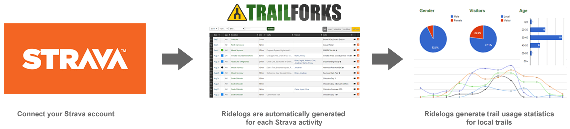
Do you use Strava? If so, we urge you to connect your Strava account with Trailforks. Why you ask?
Trailforks provides you great statistical analysis (more than Strava) including ride history, trails ridden, and year over year data
Trailforks provides us an organization incredible data that we can use to plan future trails, maintain trails, and powerful information to present to local land managers and municipalities

 (1)")