
Since the Town of Eagle Open Space & Trails Master Plan was approved in July 2022, we have been working with the Hardscrabble Trails Coalition (HTC) on some proposed trail improvement projects. The HTC has hosted multiple meetings to garner feedback and we’ve shared these plans through multiple outlets since November last year. Now the time has come for it to go through its final review with the Bureau of Land Management (BLM).
First let’s talk about some land management policy background, the plans immediate goals, long-term “Phase 2” goals, and then details on these trail projects. Finally, how to comment on the project before it closes on July 9th.
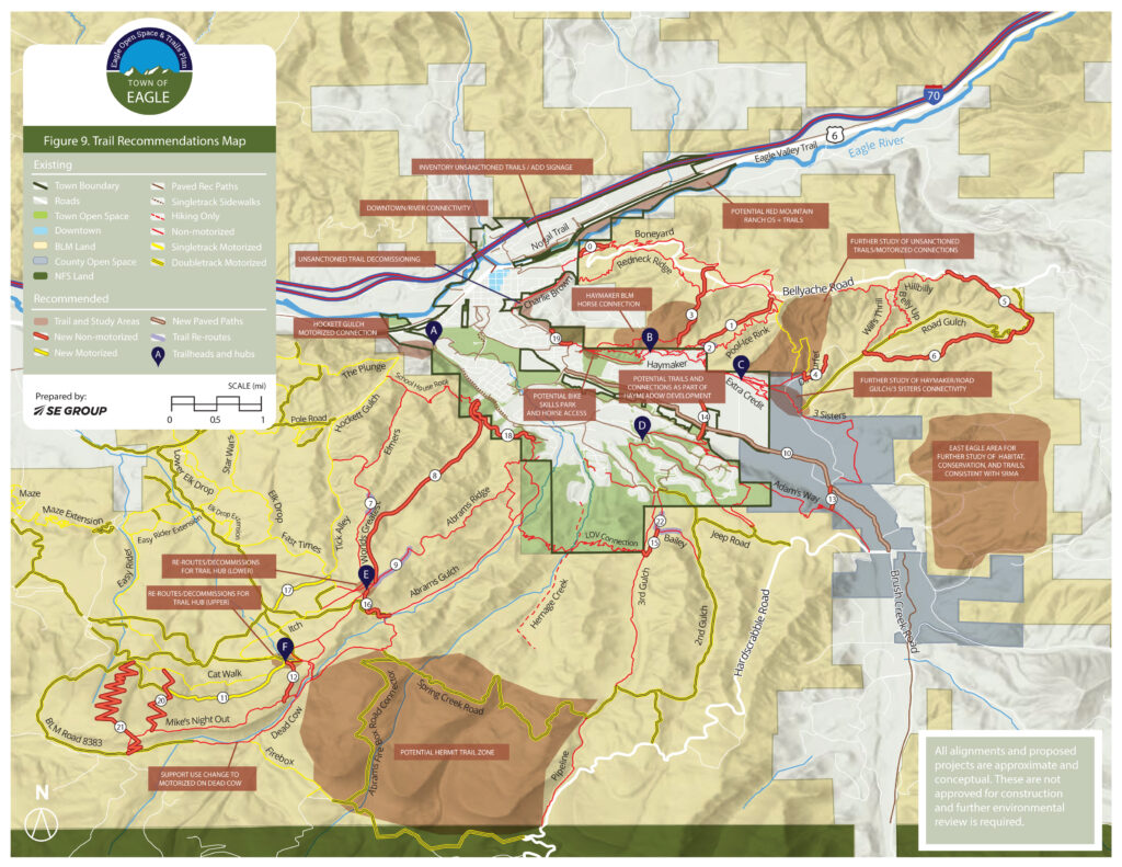
BLM Special Recreation Management Area (SRMA):
In short, the areas around Eagle that we enjoy trails like Boneyard, Pool & Ice, Mike’s Night Out, Abrams Ridge, World’s Greatest, and more are primarily located on BLM public lands. The BLM manages the areas that these trails are in as SRMA’s. Per their 2015 Resource Management Plan, 12-15 miles of trail can be built in this SRMA. With the recent additions of Belly Up, Hillbilly, and Will’s Thrill, that allocation is down to 11(sh) miles.
This Phase 1 plan cleans up the existing trail system with some strategic reroutes, trail hubs, trail system connections, and decommissions. Reroutes are a net gain/loss when applied to the 11 miles remaining to build. A reroute consists of decommissioning and building a new section of trail. If the new section is longer than the reroute, then mileage is subtracted from the 11 miles, and vise versa. Decommissioning of legal trails also allows us to bank additional miles for new trails.
Immediate Goals:
The project focuses on achieving six objectives identified as “High Priorities 0-3 Years” for the Eagle area trail system as identified in the Town of Eagle Open Space and Trails Master Plan .
- Trail Hub development with improved navigation and signage
- Re-routes of eroding, unsustainable trails
- Unsanctioned trail management
- Trail maintenance collaboration
- Habitat improvement projects
- Motorized access
Phase 2 Goals:
Once these Phase 1 projects are complete and the trail system is cleaned up, connected, and maintained, the HTC plans to propose a new trail construction plan. This new trail construction will again be in line with the Town of Eagle Open Space & Trails Master Plan vision. It includes many exciting new trail opportunities such as a climbing trail from the Haymaker trailhead, a blue/black downhill alternative near Pool & Ice, a “Hermit Zone” trails hub in pines and aspens, and much more.
Needless to say, our trail concepts add up to more than 11 miles of trail. To propose these trail projects, decommissioning of existing trails that are not used, encroach critical wildlife habitat, and cause negative impacts should be closed and their mileage banked towards new, future trails.
Phase 1 Details:
East Eagle – Hardscrabble SRMA RMZ 1
The proposed projects in East Eagle focus on re-routes, maintenance, unsanctioned trail management, and trail decommissions. East Eagle is the most used trail area in Eagle making these projects a top priority in order to maintain a high-level user experience in this area. The recent acquisition of the Brush Creek Valley Ranch and Open Space borders a significant portion of the East Eagle Hardscrabble SRMA RMZ #1. The Brush Creek Valley Ranch & Open Space management plan was adopted in 2017 after a community input process. This management plan drives the current and future values of the area “that preserve our region’s ranching heritage, visual character, and landscapes of the Brush Creek valley. The property protects wildlife habitat and provides opportunities for public access, recreation, and education for future generations.” The 7-8 miles of proposed decommissioned trails in this area will prioritize this land for wildlife habitat by connecting a broad landscape scale habitat and limiting recreation use in the area.
Re-Routes & Maintenance
- Good Bit – creates a singletrack connection from the Bluff’s neighborhood to Boneyard, bypassing steep, lower Bellyache Road. With increased motorized use of Bellyache this project will decrease user conflict and provide a better user experience by connecting the neighborhood to the Boneyard trail with access that is characteristic of the actual trail.
- Dirt Surfer and Dirt Surfer Shortcut – In partnership with Rocky Mountain Sports Riders (RMSR) and Eagle County Open Space, we are proposing to decommission and re-route Dirt Surfer. With the recent acquisition of the Brush Creek Valley Ranch and Open Space (BCVROS) by Eagle County, part of Dirt Surfer crosses onto the property which doesn’t allow motorized use. The reroute alignment will be in the general area of the unsanctioned trail Burn After Riding to create a legal, more sustainable trail alignment. The reroute will attempt to retain the steep, intermediate/expert characteristics of the original trail. The reroute will be non-motorized access. This change will limit motorized use to Bellyache Road and Road Gulch.
- Road Gulch Reroute (Partial) – with the purchase of the BCVROS, motorized users can no longer access Road Gulch from Haymaker. The only motorized access to Road Gulch is from Bellyache Road above. In order to eliminate user conflict and illegal motorized use on BCVROS, we propose decommissioning the road below the intersection of Will’s Thrill and rerouting to non-motorized singletrack. This will help prevent illegal motorized use of the trails on Haymaker and BCVROS. This will also provide a fun singletrack option after riding Will’s Thrill!
Unsanctioned Trail Closure
The demand for trails in this area is supported by the disproportionate development of unsanctioned trails. Unfortunately, these unsanctioned trails are unsustainable and have poor alignments. We are exploring new trail alignments for future projects in order to meet the demand and desired user experience. An illegal trail in the area known as “Braaap” will be closed and decommissioned. As part of the Dirt Surfer Reroute ( explained above), the illegal trail known as “Burn After Riding” will be closed with the Dirt Surfer Reroute new trail alignment occurring in the same area.
Decommission
The following is a list of the underutilized roads we propose to decommission. These roads have a history of promoting illegal trail creation. With the newly acquired BCVOS property, the decommissioning of these trails is the start of restoring habitat in the area. The proposed decommissions are best viewed on the map but include BLM 8412, 8412A, 8412AA, 8413E, 8413G, 8413D, 8413BA, 8413B, 8413, and 8413BC. If approved, further exploration for habit restoration after the decommission will be discussed in partnership with key stakeholders.
West Eagle – Hardscrabble SRMA RMZ 1
The proposed projects located in West Eagle focus on developing two new trail hubs, reroutes of unsustainable trails to improve intermediate access, improving motorized connectivity to decrease user conflict, and various related decommissions. The trails in West Eagle are less popular than the trails in East Eagle. User feedback indicates that a lack of signage and the presence of a number of spurs/trail connectors make it difficult for local users and visitors to navigate. Additionally, the primary access to the area, Abrams Ridge, is an intermediate/advanced trail making it extremely challenging for beginner/intermediate riders to access the area. These projects will ultimately improve the user experience for both non-motorized and motorized use by providing better navigation, intermediate access, connectivity, and signage to direct the user experience.
Reroute – Trail Hub #1 “Shire” or “Cow Camp” Trail Hub – Catwalk/Mikes Night Out/Blue Grouse/Scratch
The trails in this area are infamously hard to identify and navigate unless you are riding with someone who knows them. The idea is to reroute existing routes so they all connect, and start/end in one location with appropriate maps and signage improving the user experience. With signage and proper use designation, the hope is to eliminate the illegal motorized use of the area, while providing additional legal motorized use, and decreasing the potential for user conflict. The details of the reroutes are as follows:
- Blue Grouse – Extend Blue Grouse from the BLM road 8383d down into Catwalk as it connects to the Shire. Decommission the existing illegal section that connects into Mikes Night Out to help prevent illegal motorized use of Mikes Night Out and provide a legal motorized trail alignment that creates a new loop option with Catwalk. The local motorized community has long desired motorized trail options that are located within a “forest environment” as opposed to the majority of West Eagle which contains dusty, dry, Gypsum type of soils.
- Mikes Night Out – reroute the steep, eroding end section of Mikes Night Out away from the Abrams Creek watershed to connect into the Shire. Close (not decommission) existing .59 miles of trail on utility road that parallels the Abrams Creek watershed. This utility road was created to provide a water drinking source for the Town of Gypsum. Currently, many motorized users access this section of trail/road to climb up Mikes Night Out (illegally) and have also created illegal trails crossing Abrams Creek to connect to Dead Cow. Crossing Abrams Creek not only has the potential to negatively affect the water supply but also negatively affects the known populations of Native Cutthroat Trout located in Abrams Creek.
- Scratch – reroute scratch to connect with the Shire location and decommission existing sections of Scratch.
- Reynolds Wrap Extension – extend the trail as it approaches Spring Creek Road so that it connects with Scratch and into the Shire hub.
- Abrams Gulch Reroute – reroute the upper section of Abrams Gulch and build new singletrack that connects with the new World’s Greatest Trail Hub. Decommission/Close steep Abrams Gulch road (.57 miles). This project will help provide better, intermediate access from LOV Connection, up Abrams Gulch into the Shire Trail Hub. It will also eliminate a creek crossing over Abrams Creek reducing the impact on that watershed.
Reroute – Trail Hub #2 Worlds Greatest Trail Hub – Abrams Ridge/Itch/Scratch/Worlds Greatest/Yellow Chair
As with the trails identified for the Shire hub, the trails in this area are infamously hard to identify and navigate. The idea is to reroute existing routes so they all connect to the Shire Trail Hub. Improved maps and signage would be created with the goal of improving the user experience. With improved signage and proper use designation, the hope is to eliminate the illegal motorized use of the area and decrease the potential for user conflict all while improving the user experience by creating a connected singletrack trail system. The details of the reroutes to accomplish this goal are as follows:
- Abrams Ridge Extension – extend the top part of Abram’s Ridge by rerouting the existing doubletrack track into a new singletrack and connecting to the Worlds Greatest Trail Hub. Decommission existing double track road.
- Itch Reroute – Close and decommission the Itch trail below Worlds Great and reroute it to the Worlds Greatest trail start.
- Scratch Extension – extend Scratch singletrack to connect with Worlds’ greatest and new proposed Itch start.
Motorized Connectivity
The trails in the West Eagle Hardscrabble SRMA RMZ #1 and RMZ #2 have historically been built and used by motorized users. The organic nature of the development of these trails, lower usage by non-motorized users, and lack of trail signage/use designation have created an environment where you can regularly encounter a motorized user on a non-motorized trail. The goal of these projects is to provide better connectivity for motorized users. It will also separate the two uses to help prevent user conflict ultimately improving the trail experience for all users.
- 8384B – Decommission existing road that is currently close to motorized use and leads to a dead end.
- Mikes Night Out Hike-a-Bike Reroute – Not only is this an impossible pitch for most humans to ride up on their bike but increasingly moto’s and OHV’s are on this section of trail that is designated for non-motorized use. The reroute will provide a ridable climb and will prevent motorized use.
- Blue Grouse – Decommission the existing illegal section that connects into Mikes Night Out to help prevent illegal motorized use of Mikes Night Out coming up the trail.
- Dead Cow and Firebox Singletrack – Open to dirt bikes to improve the connectivity of motorized loops in the area.
- Firebox Alternative – Close illegal trail and provide motorized access iva Dead Cow and Firebox Singletrack
Eagle Ranch – Hardscrabble SRMA RMZ #1 ACEC
We have two projects proposed for this special area of the Hardscrabble SRMA RMZ #1 as they both exist with the Area of Critical Environmental Concern (ACEC).
- Water Tank Trail/Riddle Area – a social trail has become popular with dog walkers from the Highlands area that connects the water tank road to Hardscrabble Road and connection to Riddle. We plan to decommission this illegal trail per the BLM’s Resource Management Plan identifying this area as an Area of Critical Environmental Concern (ACEC).
- We had proposed rerouting 3rd Gulch to sustainable singletrack instead of the eroding, widening road. Unfortunately, the BLM did not accept this as part of the proposal due to it’s location in the ACEC and potential negative impact on Harrington’s Penstomon
Submit Your Substantiative Comments – Due July 12th
What is a substantiative comment you ask?
Substantive comments do one or more of the following:
- Provides new information or data relevant to the project.
- Identifies or helps refine planning issues.
- Identifies—based on factual evidence—potential inaccuracies or deficiencies in the information presented for scoping.
- Proposes reasonable alternatives other than those proposed for analysis.
- Causes changes or revisions to one or more alternatives.
With that in mind, if you have a substantiative comment, you can comment on the proposed projects here.
Do You Have Non-Substantiative Comments? Reach out to discuss them with us here.
Social media comments don’t do anyone any good!
 (1)")

I’m really encouraged to see the planned improvements and am grateful for all of the effort being put in. One thing I don’t see is regarding free range cattle management. Some of the best trails (eg. Pipeline) are often rendered unusable due to free range cattle. They destroy the trails and vegetation, leave feces everywhere, and befoul the waterways. Ranchers who allow their cattle in these areas should be held responsible for cleaning up after their animals and repairing the damage. Perhaps this could be accomplished by a permitting system, where ranchers buy permits per head per day to defray the cost of repairs. There could also be limits set on the number of head per hectare to reduce damage. And if cows are found without permits then they could be rounded up and auctioned off with the proceeds going to repair damage and trail maintenance. Alternatively, fences could be erected alongside the trails to prevent cattle from using them. This is just a few ideas, I’m sure there are others. Needless to say, SOMETHING needs to be done to address this, so users have full access to the trails.
Pingback: Vail Valley Mountain Trails Alliance plans ‘Trails For All. Trails Forever!’ fundraiser | VailDaily.com
The town of Eagle created and placed a large bubble in the the BLM East Eagle Special Recreation Management Area “East Eagle Area for Further Study of Habitat, Conservation and Trails, consistent with SRMA. When is the town of Eagle going to start this study, who will be conducting the study, what is the scope and time frame of the study?
The town of Eagle created a large bubble in BLM federal lands East Eagle Special Recreation Management Area “East Eagle Area For Further Study of Habitat, Conservation and Trails Consistent With SRMA”. When will the town of Eagle start this study, who will be conducting the study, what is the duration and scope of the study?
Any idea what the study is even about or who will be paying for the study? Also how long will it take?
Pingback: Construction kicks off at the Eagle Bike Park, with 9 jump lines taking shape | KSKE Ski Country
Pingback: Construction kicks off at the Eagle Bike Park, with 9 jump lines taking shape | La Nueva Mix
Pingback: Construction kicks off at the Eagle Bike Park, with 9 jump lines taking shape | KKCH – The Lift FM